Sunday, July 30, 2006

Denali

I left Fairbanks and headed south on Hwy 3 (the Parks Highway) to Denali National Park. I arrived around 5pm (still plenty of light) and booked a flightseeing ride on a small plane. It was sunny and warm, so I took off in the Jeep south, hoping to see Mt. McKinly (otherwise known as Mt. Denali). Little did I know that the first viewing of this mountain was over 100 miles away! I drove south for about 20 miles and took some nice pictures of the surrounding "hills":


The scenery was really beautiful. Around 8pm, a group of us went up in a small plane for an hour flight to check out Denali. Here we are approaching our aircraft:


It took as about 25 minutes of flying time till we got to the mountain, which was surrounded by clouds. The mountain itself was very nice, but the entire flight to and from the mountain was even more beautiful:


Denali


I was lucky I made the flight that day, because the next two days were miserable, weather-wise. The entire mountain range was shrouded with clouds, rain, and 50 degree weather. I didn't see so much as a hill after that flight! So, my advise is to skip Denali unless the weather is nice!

Arctic Circle

I arrived in Fairbanks, but there really wasn't much to see in town. So, I decided to drive up north to the Arctic Circle, which was only 200 miles away. The first 85 miles from Fairbanks was on a very nicely paved road (Hwy 2) and connected me to the Dalton Highway.


The Arctic Circle lie 115 miles up on this "highway", the first 80 miles or so unpaved. When I say "unpaved" what I really mean is "hell". I took my Jeep through the most punishing road conditions yet on the trip. It was advised to take along 2 spare tires with you. The memory of being stuck with a flat in Telegraph Creek reminded me that my tires were not in the best of shape.


Above is a shot of the "war zone" that I had to pass. They were doing construction on a 12 mile stretch that required an escort vehicle in front to guide the cars through. I had to wait 30 minutes on the way back because I had just missed the previous line of cars going through.

Once cool thing along the entire length of the road was the Alaskan pipeline, pictured below:


It wound its way over hill and dale, and sometimes dissapeared through the hills. The oil enters the pipeline 300 miles north of here at the coast in a town called Barow. The oil is 180 degrees F as it enters the pipe and cools along the way. The pipeline is suspended over the ground so as not to thaw it and has radiators every few feet to dissapate the heat. The oil continues another 500 miles to the southern coast, to Valdez. Pretty impressive!

Anyway, after 60 miles of hellish road, I finally made it to the Arctic Circle. Not much there, except rolling tundra and this sign:


The Jeep took quite a beating, but luckily, no flat tires!

Saturday, July 29, 2006

Onto Fairbanks, Alaska

Well, I left Dawson City (had to cross the Yukon River on a verrrry small ferry). The highway between Dawson City and (ultimately) Tok, Alaska, is Hwy 5, otherwise known as the "Top of the World" highway. It called that because the road rides along the spine of a mountain range, and has sweeping views on both sides. The Alaskan border lie 60 miles from Dawson, about half of it unpaved - a now-dreaded road condition that has been occurring more frequently and without forewarning from maps or other sources of information. It was a pretty rough ride for those 30, unpaved miles, but I finally reached the border!


The border guard told me that the road would stay unpaved for the next 43 miles, and that it would get worse. He was right. I crawled along very slowly (about 15 mph) for the first 3 miles, and then came upon a little "gift shop":


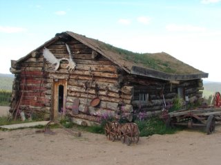
It was manned by a middle-aged guy who actually lived there year-round. There's nothing around for miles.

Anyway, I continued crawling along in the RV, things rattling, bouncing...I lost my coffee pot from its perch with some coffee in it from that morning...got all over the couch, the carpet, etc. A real mess! The road continued its violent assault for only the next 20 miles or so, then it mellowed out a bit, allowing me to make up some lost time. I passed the town of Chicken (population 25), then it was onto Tok, Alaska.

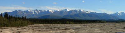
Not too much to see in Tok. I got some fuel and continued on to Fairbanks, which was about 230 miles away. It wasn't going to be dark until midnight, so I had plenty of daylight to drive by. It turned out to be a very nice drive:


I also saw a momma and baby moose (my second pair since arriving in Alaska):


A little while later, I guy driving the other way started flashing his lights at me. I immediately slowed down, thinking that there might be an animal on the road or something. I was right:


This guy was huge!

I drove a little while longer, getting the following shots: Really beautiful!

I pulled off to the side of the road, about 100 miles short of Fairbanks, and spent the night.


r

Wednesday, July 26, 2006

Dawson City

After my visit to Skagway, I became interested in the Gold Rush that occurred in this area in 1898-1900, so I detoured north to Dawson City, which is where all of the "stampeders" were heading. This was a town that sprang up "overnight" due to the influx of people hoping to strike it rich. Just before I arrived in town, I spotted a huge porcupine and an otter playing in the river:


The town still had some very old buildings left over from the Gold Rush days:


There was also a very large, and very old, cemetary where many of the original townsfolk are buried:


There were many graves that were unmarked, some of the old wooden crosses had writting too faint to make out, and I was surprised of the number of children who only lived a very short time, i.e., 1 day, 3 days, etc.

Well, enough of that! I also had to try my hand at panning for gold. I drove out quite a ways to a working goldmine called Goldbottom. The modern way to mine for gold is to literally sift through tons of rock, gravel, and sand to find a few slivers of gold. There are many steps to removing the gold from all that muck. It starts with a backhoe depositing huge amounts of dirt into a giant machine that shakes and washes the dirt, producing a concentrated "sluce". After two weeks of effort, generating about 100, 5 gallon buckets, the sluce is then refined by hand to finally separate the gold dust and flakes. Here is the backhoe and giant shaker machine in action:


And here's the old fashion way:


I panned for about an hour and actually got a couple af flakes! It was back-breaking work! Very fun little tour though!

Friday, July 21, 2006

Skagway, Alaska

I travelled from the junction of Hwy 37 and Hwy 1 (the Alaskan Highway) to Whitehorse, a rather large town, about 270 mile journey. What a pleasure it was to drive on a nice, paved road, able to go 60 mph again! Made the trip with no incidents, and had some nice scenery along the way.

While camping in Whitehorse, I took a bus/train ride south about 100 miles to the town of Skagway, Alaska. It was a beautiful drive, and I wish I had taken the Jeep so I could take some pictures. But, we did stop in a place called Carcross, a tiny little town, and I got these pictures:


We left Carcross on the bus, and traveled further south to an even smaller town called Fraser. That's where we boarded a very old train from the early 1900s. The train wound its way through the mountains for about an hour to Skagway.


Skagway was quite the tourist trap. There were many buses and a few gi-normous cruise ships. Tourists clogged the streets. It was nothing except souvineer shops everywhere. I only spent about 10 minutes wandering around, and then went to the Red Onion, which was a bar dating over 100 yrs old. It had also been a brothel, with little rooms upstairs. Naturally, I took the 10 minute tour to find out more. They had some girls dressed up as ladies of the day, and I took this photo of them:


I hung out at the bar for the afternoon, then boarded the bus for the long ride home. The train ride was probably the highlight of the trip.

Telegraph Creek

Well, I arrived in Dease Lake and spent the night in a regular RV campground that wasn't much to write home about. The next day, I took a 70 mile (one way) side trip down an unpaved road to a place called Telegraph Creek. It was a very rough road for the Jeep, and I stopped a rest area exactly half way there. I noticed some bear droppings only about 20 yards up a little trail at the rest stop. As I returned to the Jeep, I noticed:


I was in the middle of nowhere, and didn't know if I was going to make it out easily, or if at all. I uncovered my spare tire on the back of the Jeep to find...a beautiful, new tire! The only problem was that it was held in place with a locking wheel lug! I didn't remember ever seeing one in the Jeep, so I thought I was sunk. But, I looked in the glove box and there it was! Awesome! I was able to change the tire in about 30 minutes, constantly looking over my shoulder for the bear that was in the area. In the time I took to change the tire, not one car passed either way on the road.

Anyway, I was up and going the rest of the way to Telegraph Creek, which was at one time going to be a major telegraph central location, way out in the middle of nowhere. Along the way, I ran into a bunch of horses that were just having a good 'ol time on the road:


As I got near Telegraph Creek, the views began to get better:


There was a huge canyon several miles long as I approached, containing a beautiful river. Here's one shot of the canyon:


Telegraph Creek is tiny. I took some photos of an old church and had a great lunch.


There were lots of buildings dating back to the 1800s still standing.

Enough of that. I drove the 70 miles back to the RV, parked in a rest area. Then, around 6pm, headed north out of Dease Lake. Destination: the junction of Hwy 37 and Hwy 1, the Alaskan Highway! As I drove, I saw 2 moose, a beautiful tan fox, two bears, and a wolf. Not to mention, of course, the beautiful scenery:


Highway 37 to Dease Lake

Hi again all - So, after my visit to Stewart/Hyden, I travelled back along Hwy 37a to Hwy 37 and continued north. I've been seeing a lot more wildlife on the roads because I've started to drive after 6pm, when the animals come out. It doesn't get dark in these parts until midnight or so, so I've got plenty of light to drive by. Here are some shots along Hwy 37 heading up to Dease Lake:


A black bear posing for me.


Great scenery for much of the drive.


A postcard for you...


Hodder Lake rest area. This lake breathtaking!

I actually pulled over in a gravel parking lot on my way to Dease Lake to spend the night. It was a little weird being all alone, not knowing if anyone would come a knockin. No one did, and I got on the road in the morning with no problems.

Friday, July 14, 2006

Stewart, BC and Hyden, AK

After I left Prince Rupert, I travelled back along Hwy 16 heading east and took Hwy 37 north. About 90 miles into Hwy 37, there was a turnoff to Hwy 37a to Stewart, BC and Hyden, Alaska, which is only about 2 miles past Stewart. Really small towns here. Very nice! Hwy 37a is known as the glacier highway, for obvious reasons. It was a really great drive to Stewart:


Saw this guy along 37a


One of the highlights down here is a 25 mile drive up to Salmon Glacier. Here are some pictures of that trip:


Here are a few shots of the area around Stewart/Hyden:


There's been a lot of rain and cool weather up here. They consider it a rainforest. No doubt!